Satellite imagery has long been dismissed as a tool reserved for meteorologists, military strategists, and climate scientists. That assumption is wrong, and it's costing treasure hunters and archaeological researchers real discoveries. Today, satellite data analysis is one of the most powerful methods for identifying buried settlements, lost roadways, and high-probability treasure zones, all from a desk before you ever set foot in the field. This article breaks down what satellite data analysis actually is, which tools and methods matter most, how it reveals hidden sites in practice, and what ethical responsibilities come with that power.
Table of Contents
- Satellite data analysis defined
- Tools and methods for satellite analysis
- How satellite data reveals hidden sites
- Ethics, pitfalls, and responsible disclosure
- Why most treasure hunters underestimate satellite data
- Start your satellite-powered treasure hunt
- Frequently asked questions
Key Takeaways
| Point | Details |
|---|---|
| Satellite data is accessible | Even amateur treasure hunters can use satellite data to uncover clues about historical sites. |
| Change detection helps protect | Monitoring satellite images reveals new threats like looting, aiding preservation efforts. |
| Integrating old and new data | Combining legacy and modern satellite imagery gives a fuller picture of site evolution. |
| Ethical disclosure is critical | Careful management of site information prevents looting and supports conservation. |
Satellite data analysis defined
At its core, satellite data analysis means reviewing imagery and sensor data collected from orbiting platforms to identify anomalies, terrain shifts, and potential man-made features on or just below the Earth's surface. For treasure hunters and archaeological researchers, this translates into a systematic way to spot what ground-level observation misses entirely.
Three primary satellite types drive most of this work:
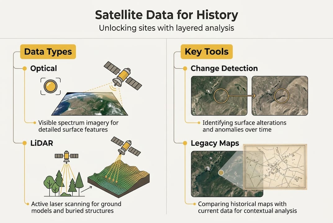
- Optical satellites capture visible-light imagery, similar to aerial photography but at global scale. They're ideal for spotting surface features like crop marks, soil discolorations, and structural outlines.
- Radar satellites (SAR) use synthetic aperture radar to penetrate cloud cover and, in some cases, dry sand or soil. SAR is particularly effective in desert environments where ancient features are preserved beneath thin sediment layers.
- Multispectral satellites record data across multiple wavelength bands beyond visible light, including near-infrared. This reveals vegetation stress patterns that often indicate buried foundations or disturbed soil.
The practical applications for your research include:
- Detecting surface disturbances caused by past human activity
- Mapping the full spatial extent of a potential site before committing to fieldwork
- Monitoring threats like looting, urban encroachment, or erosion that may destroy evidence
- Comparing historical and current imagery to track site changes over decades
| Satellite type | Best use case | Key limitation |
|---|---|---|
| Optical | Surface feature mapping | Blocked by clouds and vegetation |
| Radar (SAR) | Subsurface penetration in arid zones | Complex data interpretation |
| Multispectral | Vegetation stress and soil anomalies | Requires spectral analysis software |
Satellite data does not work in isolation. Learning to read LiDAR data alongside satellite imagery dramatically sharpens your ability to confirm terrain anomalies. Similarly, AI metal detecting tips show how layering data types produces far more reliable target zones than any single source alone.

Pro Tip: Always pair satellite imagery with local historical records, soil surveys, or oral histories. Satellite data tells you where something unusual exists. Ground knowledge tells you why it matters.
Tools and methods for satellite analysis
Knowing what satellite data analysis is only gets you so far. The real advantage comes from knowing which tools to use and how to sequence your workflow.
Major tools available to researchers:
- Google Earth Engine provides free access to decades of Landsat and Sentinel-2 imagery with built-in analysis tools
- NASA Worldview and GIBS offer near-real-time multispectral data for global coverage
- OpenTopography hosts high-resolution elevation datasets useful for terrain context
- CORONA declassified imagery from the 1960s and 1970s shows landscapes before modern development altered them permanently
- Commercial platforms like Maxar and Planet Labs offer sub-meter resolution imagery for precision targeting
Here is a practical step-by-step process for applying these tools:
- Access your data. Start with free sources like Google Earth Engine or USGS Earth Explorer. Download multispectral or optical imagery for your target region.
- Preprocess the imagery. Apply atmospheric correction and band compositing to normalize the data and reduce noise from atmospheric interference.
- Analyze with software. Use QGIS or ArcGIS to run spectral analysis, change detection algorithms, and overlay historical imagery layers.
- Interpret your findings. Look for geometric shapes, linear features, or soil color anomalies that don't match the natural landscape pattern.
- Cross-reference with other datasets. Combine your satellite findings with LiDAR terrain models, historical maps, and land records before drawing conclusions.
One of the most underused strategies is integrating legacy data like CORONA imagery with modern satellite images for diachronic analysis, meaning you compare the same location across different time periods. Features visible in 1965 CORONA imagery that have since disappeared under vegetation or development are often the most valuable leads.
For those new to the field, reviewing metal detecting basics helps contextualize what you're looking for at ground level, while LiDAR treasure hunting explains how elevation data complements satellite imagery in site identification.
| Dataset | Temporal range | Resolution | Cost |
|---|---|---|---|
| Landsat | 1972 to present | 30 meters | Free |
| Sentinel-2 | 2015 to present | 10 meters | Free |
| CORONA | 1960 to 1972 | 2 to 8 meters | Free (declassified) |
| Maxar WorldView | 2007 to present | 0.3 meters | Commercial |
Pro Tip: Run change detection between imagery from different years, not just different seasons. A fresh disturbance pattern from two years ago that wasn't present in older imagery often signals recent human activity, whether legitimate or illegal.
How satellite data reveals hidden sites
Theory is useful. Real results are more convincing. Satellite data analysis has produced concrete discoveries across multiple continents, and the methods are directly applicable to treasure hunting and archaeological research.
Archaeologists working in the Middle East have used multispectral imagery to identify ancient settlement patterns invisible at ground level, including road networks, field systems, and building foundations buried under centuries of sediment. In South America, SAR imagery has revealed pre-Columbian earthworks in the Amazon basin that were completely hidden beneath dense forest canopy. These are not isolated cases.
Here are specific applications where satellite analysis has delivered results:
- Ancient road detection: Linear soil anomalies in optical imagery have traced Roman roads and pre-Columbian trade routes across hundreds of miles
- Burial mound identification: Subtle circular crop marks in multispectral imagery indicate disturbed subsoil consistent with burial mounds
- Lost settlement mapping: Geometric patterns in vegetation stress data reveal foundations of structures abandoned centuries ago
- Cache site targeting: Terrain depressions identified through combined satellite and LiDAR data correspond to historically documented hiding locations
- Illegal excavation monitoring: Freshly disturbed soil signatures appear clearly in change detection analysis
Researchers interested in cipher-based treasure legends, like those surrounding the Beale cipher, can use satellite terrain analysis to narrow candidate locations based on geographic clues embedded in historical documents. Similarly, sites like Canyon Diablo benefit from satellite-based landscape analysis to identify terrain features consistent with historical accounts.
Change detection analysis has revealed looting activities across conflict zones, including the identification of thousands of new excavation pits in Syria, as well as urban encroachment threatening sites across multiple regions.
This capability cuts both ways. The same tools that help you find sites also reveal when those sites are being actively destroyed, which is exactly why responsible use matters.
Ethics, pitfalls, and responsible disclosure
Satellite data analysis gives researchers a significant advantage. That advantage carries real responsibility, and many newcomers underestimate how quickly poor decisions can cause lasting harm.
The most critical rule is straightforward: do not publicly share precise coordinates of vulnerable or unexcavated sites. Responsible disclosure means carefully managing what information you release and to whom, because publishing site locations, even inadvertently through social media posts or forum discussions, can trigger looting within days.
Legal frameworks add another layer of complexity. In the United States, the Archaeological Resources Protection Act (ARPA) governs excavation on federal and tribal lands. Internationally, UNESCO conventions and bilateral agreements regulate what can be removed, reported, or disclosed. Regulations vary dramatically by country, and ignorance is not a legal defense.
Here are the most common pitfalls for new satellite data users:
- Misidentifying natural features as man-made. Geological formations, erosion patterns, and agricultural field boundaries frequently resemble archaeological features in imagery.
- Over-relying on a single data source. One satellite image rarely tells the full story. Confirmation requires multiple datasets and ideally ground verification.
- Ignoring temporal context. An anomaly visible today may be a modern irrigation ditch, not an ancient canal. Always check the historical record.
- Skipping legal research. Assuming land is accessible or that findings are yours to act on without checking ownership, permits, and applicable laws is a serious mistake.
- Sharing prematurely. Posting potential site locations online before proper verification and legal consultation puts both the site and your credibility at risk.
For broader context on regulations, research practices, and community standards, the treasure hunting articles on PinPoint Treasure cover a wide range of legal and practical considerations relevant to field researchers.
Pro Tip: Before planning any ground search based on satellite findings, cross-reference your anomaly with at least two independent data sources and consult a local archaeologist or land management authority. One data point is a hypothesis. Three converging data points are a target worth pursuing.
Why most treasure hunters underestimate satellite data
Here is an uncomfortable truth: most treasure hunters treat satellite imagery as a visual confirmation tool rather than an analytical one. They pull up Google Earth, look for something that resembles a mound or depression, and call it research. That approach misses roughly 90% of what satellite data can actually reveal.
The real power lies in temporal layering. Integrating legacy and modern satellite data provides critical context that no single image ever could. A feature visible in 1968 CORONA imagery that has since been plowed under or built over is not gone from the record. It's preserved in the data, waiting for someone who knows how to look.
Change detection is equally overlooked. Most researchers focus on what a site looks like now. The more revealing question is what changed, when, and why. Sudden disturbances, vegetation shifts, and soil exposure patterns are often the clearest signals of buried activity.
The best outcomes consistently come from layering optical, multispectral, and radar data, then combining those findings with LiDAR terrain models, historical maps, and local expert knowledge. No single tool wins. The combination does. Explore the full range of platform features available to support exactly this kind of multi-source analysis.
Start your satellite-powered treasure hunt
Satellite data analysis is no longer reserved for government agencies or university research teams with million-dollar budgets. The tools are accessible, the data is largely free, and the methodology is learnable.

PinPoint Treasure brings together AI-powered analysis, LiDAR terrain data, NDVI vegetation signatures, and anomaly visualization in one platform built specifically for researchers like you. Whether you're tracking a documented legend from the treasure legends database or running your own satellite-based site analysis, the platform gives you the data infrastructure to move from hypothesis to field-ready GPS coordinates with confidence. Start with the free tier and scale your research as your targets sharpen.
Frequently asked questions
What types of satellites are most useful for treasure hunting?
Multispectral, optical, and radar satellites are most valuable, as each type reveals different surface and subsurface anomaly signatures that complement one another when layered together.
How accurate is satellite data for locating lost treasures?
Satellite data can reliably pinpoint anomalies and surface features, but ground verification is essential for precise confirmation because imagery alone cannot distinguish between natural formations and man-made features with certainty.
Can satellite analysis detect recent looting or illegal excavations?
Yes. Change detection analysis is highly effective at identifying new pits, disturbed soil, and surface disturbances that indicate recent unauthorized excavation activity.
Is it legal to use satellite data for treasure hunting?
Accessing satellite imagery is legal, but local laws and regulations governing what you do with your findings, including excavating or disclosing site locations, vary significantly by country and land jurisdiction.
Recommended
- PinPoint Treasure — AI Treasure Hunting, Gold Prospecting & Mystery Solving Platform
- PinPoint Treasure — AI Treasure Hunting, Gold Prospecting & Mystery Solving Platform
- PinPoint Treasure — AI Treasure Hunting, Gold Prospecting & Mystery Solving Platform
- PinPoint Treasure — AI Treasure Hunting, Gold Prospecting & Mystery Solving Platform